
The Great Polish Map of Scotland

The Great Polish Map of Scotland is a remarkable and unique outdoor sculpture located near the town of Eddleston, just outside of Edinburgh. This large-scale topographical map was created as a tribute to the Polish soldiers who fought alongside the Allies during World War II and reflects a fascinating piece of shared history between Poland and Scotland.
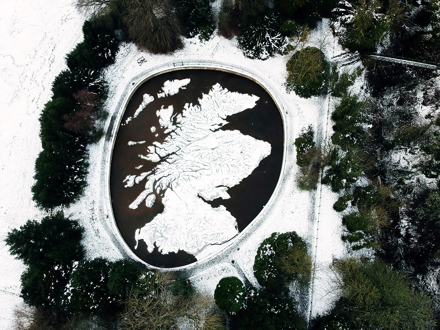
Description of the Map:
- Scale and Design:
- The map is an impressive 1:10,000 scale model of Scotland, making it the largest outdoor map of its kind in the world. It covers a substantial area, allowing visitors to see a detailed, scaled-down version of Scotland’s geography.
- The map features topographical details such as mountains, valleys, and bodies of water, sculpted in concrete and painted to highlight different geographic features. This level of detail provides an informative and interactive experience for viewers.
- Historical Context:
- The map project was led by Jan Tomasik who was part of the 1st Polish Armoured Division, under the command of General Stanisław Maczek, during World War II. The project was intended as a form of recognition and tribute to their service and to provide a lasting connection between their homeland and Scotland.
- The creation of the map began in 1974 and took several years to complete, reflecting the commitment and craftsmanship. It was ready in 1979.
- Features and Attractions:
- The map includes prominent landmarks and geographical features of Scotland, including major cities, mountain ranges, and rivers, all rendered in a way that allows visitors to visually and physically explore Scotland’s landscape.
- Visitors can walk around and even on top of the map, engaging with its topography in a tactile manner. The map is designed to be accessible and educational, making it a popular attraction for both locals and tourists.
- Significance:
- The Great Polish Map of Scotland stands as a symbol of the strong historical and cultural ties between Poland and Scotland. It represents the gratitude and respect of the Polish soldiers for their Scottish allies and the profound bond that was forged during the war.
- The map also serves as a testament to the Polish contribution to the Allied war effort and the enduring legacy of their sacrifices.
- Location:
- The map is situated near Eddleston, a picturesque village about 20 miles south of Edinburgh, next to the Barony Castle Hotel. It is easily accessible by car, and visitors can enjoy a scenic drive through the Scottish countryside to reach this unique landmark.
- Facts to remember:
- World’s Largest Outdoor Map: The Great Polish Map of Scotland holds the title for being the largest outdoor topographical map in the world. Its immense scale allows for detailed and interactive exploration of Scotland’s landscape.
- Craftsmanship and Scale: The map is built to a scale of 1:10,000. This means that 1 meter on the map represents 10,000 meters (10 kilometers) in reality. The level of detail includes mountains, valleys, and rivers, all meticulously sculpted in concrete.
- Symbol of Friendship: The map was the brainchild of Jan Tomasik, a sergeant in the 1st (Polish) Armoured Division, who had been stationed in Galashiels and had married a Scottish nurse in 1942. He became a successful hotelier in Edinburgh after the war and added Black Barony to his properties in 1968 and is thought to have stated, “I shall die, but I shall leave my map as a gift to the Scottish people to thank them for the hospitality they showed the Poles when it was needed”.
- Restoration Efforts: The map was restored and is maintained today by a group of heroes from Mapa Scotland charity formed in 2010.
The Great Polish Map of Scotland is not just a geographical representation but a poignant and enduring tribute to the friendship between Poland and Scotland. It offers a captivating blend of history, art, and geography, inviting visitors to reflect on the historical connections and the lasting impact of wartime alliances.
